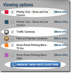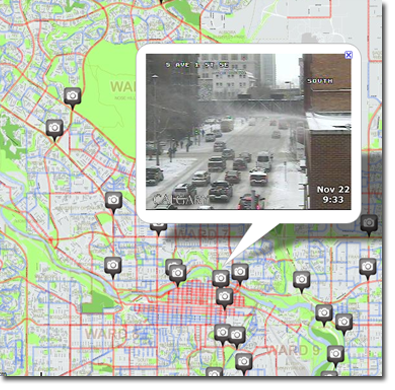
| Priority | Route | Status |
| DCE - Center | ||
|---|---|---|
| Priority 1 | Red | In Progress |
Route Description: | ||
| Priority 1 | Blue | In Progress |
Route Description: | ||
| Priority 1 | Green | In Progress |
Route Description: | ||
| Priority 1 | Black | In Progress |
Route Description: | ||
| Priority 1 | Light Blue | In Progress |
Route Description: | ||
| Priority 2 | Red | In Progress |
Route Description: | ||
| Priority 2 | Blue | In Progress |
Route Description: | ||
| Priority 2 | Light Blue | In Progress |
Route Description: | ||
| DNE - Northeast | ||
| Priority 1 | Red | In Progress |
Route Description: | ||
| Priority 1 | Blue | In Progress |
Route Description: | ||
| Priority 1 | Green | In Progress |
Route Description: | ||
| Priority 1 | Black | In Progress |
Route Description: | ||
| Priority 1 | Orange | In Progress |
Route Description: | ||
| Priority 1 | Light Blue | In Progress |
Route Description: | ||
| Priority 2 | Red | In Progress |
Route Description: | ||
| Priority 2 | Blue | In Progress |
Route Description: | ||
| Priority 2 | Green | In Progress |
Route Description: | ||
| Priority 2 | Black | In Progress |
Route Description: | ||
| Priority 2 | Orange | In Progress |
Route Description: | ||
| Priority 2 | Light Blue | In Progress |
Route Description: | ||
| DNW - Northwest | ||
| Priority 1 | Red | In Progress |
Route Description: | ||
| Priority 1 | Blue | In Progress |
Route Description: | ||
| Priority 1 | Green | In Progress |
Route Description: | ||
| Priority 1 | Black | In Progress |
Route Description: | ||
| Priority 1 | Orange | In Progress |
Route Description: | ||
| Priority 1 | Light Blue | In Progress |
Route Description: | ||
| Priority 1 | Purple | In Progress |
Route Description: | ||
| Priority 2 | Red | In Progress |
Route Description: | ||
| Priority 2 | Blue | In Progress |
Route Description: | ||
| Priority 2 | Green | In Progress |
Route Description: | ||
| Priority 2 | Black | In Progress |
Route Description: | ||
| Priority 2 | Orange | In Progress |
Route Description: | ||
| Priority 2 | Light Blue | In Progress |
Route Description: | ||
| Priority 2 | Purple | In Progress |
Route Description: | ||
| DSE - Southeast | ||
| Priority 1 | Red | In Progress |
Route Description: | ||
| Priority 1 | Blue | In Progress |
Route Description: | ||
| Priority 1 | Green | In Progress |
Route Description: | ||
| Priority 1 | Black | In Progress |
Route Description: | ||
| Priority 1 | Orange | In Progress |
Route Description: | ||
| Priority 1 | Light Blue | In Progress |
Route Description: | ||
| Priority 1 | Brown | In Progress |
Route Description: | ||
| Priority 2 | Red | In Progress |
Route Description: | ||
| Priority 2 | Blue | In Progress |
Route Description: | ||
| Priority 2 | Green | In Progress |
Route Description: | ||
| Priority 2 | Black | In Progress |
Route Description: | ||
| Priority 2 | Orange | In Progress |
Route Description: | ||
| Priority 2 | Light Blue | In Progress |
Route Description: | ||
| DSW - Southwest | ||
| Priority 1 | Red | In Progress |
Route Description: | ||
| Priority 1 | Blue | In Progress |
Route Description: | ||
| Priority 1 | Green | In Progress |
Route Description: | ||
| Priority 1 | Black | In Progress |
Route Description: | ||
| Priority 1 | Orange | In Progress |
Route Description: | ||
| Priority 1 | Light Blue | In Progress |
Route Description: | ||
| Priority 1 | Purple | In Progress |
Route Description: | ||
| Priority 1 | Brown | In Progress |
Route Description: | ||
| Priority 2 | Red | In Progress |
Route Description: | ||
| Priority 2 | Blue | In Progress |
Route Description: | ||
| Priority 2 | Green | In Progress |
Route Description: | ||
| Priority 2 | Black | In Progress |
Route Description: | ||
| Priority 2 | Orange | In Progress |
Route Description: | ||
| Priority 2 | Light Blue | In Progress |
Route Description: | ||
| Priority 2 | Purple | In Progress |
Route Description: | ||
| Priority 2 | Brown | In Progress |
Route Description: | ||
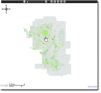
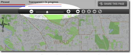
The City of Calgary - Road Conditions Map